

I find it strange how I could live on a place for years and not live in or with it. How the form of life in a suburbanized neighborhood maintained a separation from the land, a disconnection. How I could grow up not knowing the names of the places all around me, or be aware of the lives that had been lived there for centuries and millennia before. How I could be surrounded by signs of these past lives and never wonder who they were.
I never learned the name of the mountain that towered over our neighborhood in Rutland Town, VT, until I was older: East Mountain. What lay on the other side of East Mountain was a mystery to me as I gazed out at the ridge from my bedroom window. I wished I had wings so I could fly over and see. And what was it like at the summit of that other mountain that stood away from all the others to the south, with the strange strip of pines across the middle that I imagined was the window to an airplane cockpit? What was its name? As far as I knew neither prominence had been touched by human hands, and that made them all the more mysterious to me.
I couldn’t go in search of those answers but I knew every nook and cranny of the property where I grew up:
The front and back lawns I would spend hours raking and mowing, with their gardens my mom tended and the rock that served just fine as home plate in games of whiffle ball until I slid into it face first and dislodged that last baby tooth.
Our narrow driveway a trench once lined by railroad ties that we had replaced by a more elegant and (perhaps) less stable stone retaining wall where the tunnel spiders loomed, who I liked to tempt into the open by feeding them ants. When I was old enough to drive, its configuration made it a true test of my parallel parking skills. I am a highly skilled parallel parker.
The woodlot on the far side of the driveway overtopped by a giant hemlock, where I spent hours stacking firewood, to which I would be sent out into the cold with the garden cart to haul it in during the winter to keep the family warm. Where there was an obscure nook under some young trees there where I would lay on my back in the snow and listen to the quiet breeze and the chickadees who stuck around all winter.
The old maple trees we tapped only once. We boiled down the sap on our kitchen stove and the result was an extra dark syrup I would only describe as ‘Grade C.’ [The old maple syrup grading system measured hue, not quality. Due to consumer confusion it has been changed.]
The neighbor’s meadow a little larger than a basketball court that grew up to our property line, filled with goldenrod, ragweed, and milkweed.
And the dark woods, bounded by stone walls that partially obscured ancient, rusty barbed wire that we knew to step over with care. The two mossy concrete boxes, 6-feet deep, sunk into the ground with some kind of rusty tank and pumping equipment inside. The 50-foot trail that led to the fenced yard there the nuns lived, and they’d be so excited to see us and we’d talk with them about school and pet their dog. And the mysterious brook way down in the darkest depth. Where did it come from? The mountain above us? And where did it lead? It was dry half the time in the summer.
I have a hazy memory of asking my dad what was on the other side of that ridge – East Mountain – that towered over our neighborhood. So one day we got in the car and went for a drive. Apparently there was a road that led there. It was dirt, and I remember the sun flashing through the trees and craning my neck to see if there was a view of the valley where we’d come from (there wasn’t). I remember mountains around us. I remember popping out onto Route 4, the fast 4-lane road that went over Sherburne Pass to the north, but I also remember going by a country store that lay miles in the opposite direction. Maybe that was a different drive. Memory is weird like that.
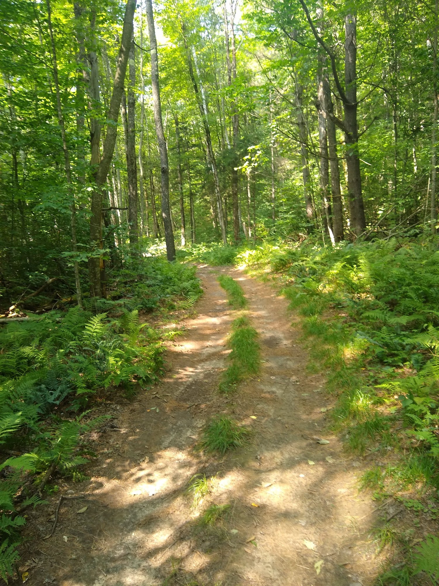
By the time I was in high school I knew that the space between East Mountain and my “airplane” mountain was called the Notch, hence the name of the road that led there – Notch Road. I don’t know whether the Notch ever had a proper name. Tamarack Notch is one candidate – there was a Girl Scout Camp up there once that bore the name. Notch Road was a steep climb that turned to dirt at the top and led to Wheelerville Road. My cross-country coach would haul our team up the Notch in the back of his pickup, deposit us at the beginning of Wheelerville Road, and then follow behind us, scooping us up one by one when it was time to wrap it up. I think I vaguely knew, without curiosity, that this was where my dad had taken me on that drive. I didn’t think about where I was. I had no sense of space or time or direction. It was just a rolling dirt road through a forest where I would struggle and sweat. There was a waterfall called McLaughlin Falls that roared off to one side, but I never stopped to look, even when some of my teammates did. Maybe I thought it would be cheating to stop in the middle of the run to see a waterfall. Maybe I had some intimation that people my age got up to no good when they ducked off the road by McLaughlin Falls, and I always tried to be a responsible kid. Today I consider being waylaid by waterfalls to be half the point of running around the woods.
I tried again to plumb the mystery of what lay beyond the Notch when I was in college. I was home for break and had a friend with me and we went for a drive. I think I was driving a rental car, and I can’t for the life of me figure out why I was driving it or where I got it in my small college town a couple hours away. A PT Cruiser, if memory serves me oddly. Maybe it was my friend’s car. On my paper map, the Notch Road kept going past Wheelerville Road, all the way to Shrewsbury, so I tried to follow it. This was in the days before GPS. The line on the map took me past an informal firing range where teenagers were drinking and blazing away and looking at me suspiciously before the road degenerated into a class 4 road – Vermont terminology for “you need a 4x4.” Suffice to say, the car wasn’t up to the task, and I found myself reversing my way out of there after bottoming out. No damage, fortunately.
The Notch Road beyond Wheelerville Road was permanently destroyed in 2011 by Hurricane Irene. All that Caribbean water dropped onto the high peaks of the Green Mountains and rushed down into the wilderness behind East Mountain, washing out the bridges on Wheelerville Road. The water crashed through the narrow slot canyon below McLaughlin Falls and blew out into the notch like a shotgun. The mountainside collapsed, carrying the road with it down into the gorge through which the North Branch Cold River roared out into the Cold River, out to Otter Creek, north to Lake Champlain, then down the St. Lawrence River to the Atlantic Ocean.
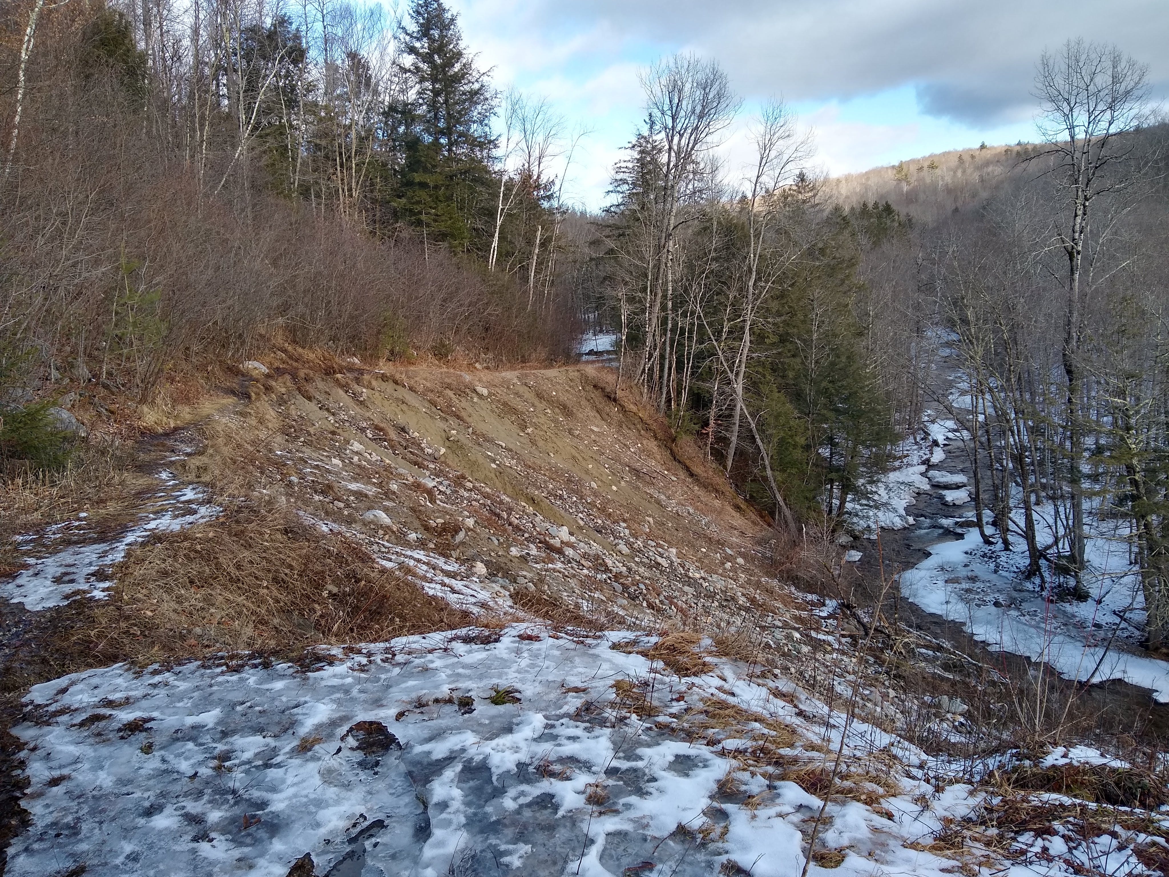
I run up the notch every time I go home. The Notch Road ends with concrete barriers that stop you from driving off the storm-smashed cliff into the creek hundreds of feet below. How could such a small creek wreak such destruction? The first time I ran there a few years after Irene there was still a little trail around the rim, but even that has collapsed over the years. The mountain is still sliding. Maybe little grains of the Notch have settled into the seabed off Nova Scotia or Newfoundland. Still, Google hasn’t updated the map. Does the internet have a way to integrate things that go away and never come back? Is there e-death for roads and mountainsides?
The remains of the road continue beyond the gap, but are only accessible by ATV or on foot via some new recreational trails built through the site of an old CCC camp (predecessor to the aforementioned Girl Scout camp) that had been obscured in the forest. On the south side of the notch they built rough hiking trails up onto Bald Mountain – the one with the belt of pines I could see from my bedroom. I’ve run to the top several times now, and I stop to enjoy the views of my hometown in the valley below and the high peaks to the south and east.
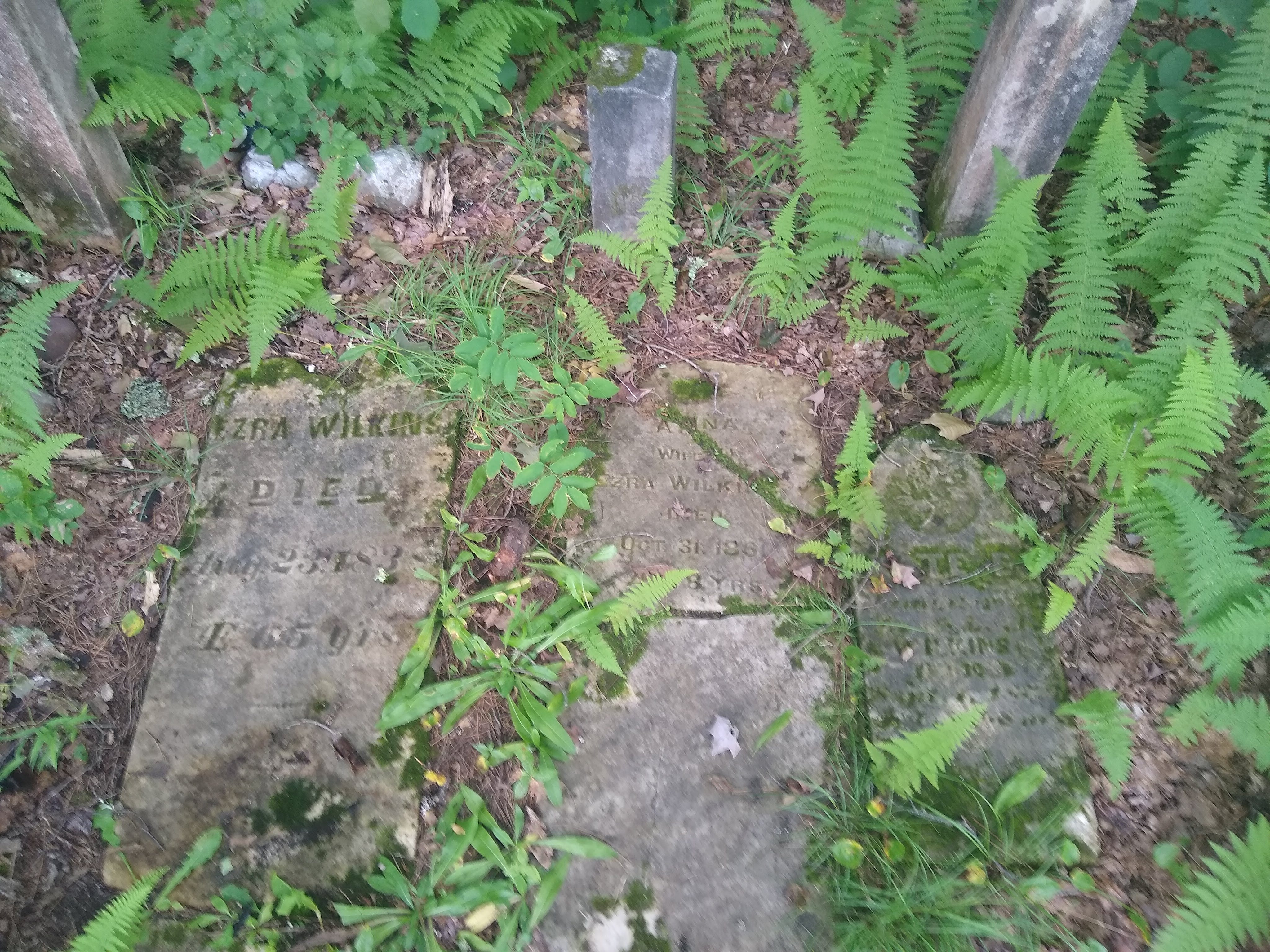
I run the ATV trails that bypass the landslide and drop down a steep slope over an old road bridge (now cut off by the landslide) and up the steep, loose, and chunky road remains beyond. As I emerge from the trees past more concrete barriers there is a tiny gravesite marked out, concealed in the weeds. “Wilkins,” the marker says. Three graves – two parents and their child, over a century ago. The road straight ahead is marked with ominous ‘No Trespassing’ signs complete with silhouettes of handguns pockmarked, of course, by bullet holes.
I divert to the north. The dirt road is well graded but residents are responsible for their own winter traction: steep hills are supplied by roadside salt barrels where motorists may stop and shovel salt onto the road should it prove too slippery to pass. When I run here in the winter I opt for shoes modified with sheet metal screws in the soles for my own traction.
My route rejoins Wheelerville Road in two miles, and when I get there I step over log barriers and past more ‘No Trespassing’ signs on the trees and approach the rim of McLaughlin Falls. The wet granite is slippery as ice and covered with dark green moss. The North Branch Cold River roars down into the cut in the rocks it has been carving for millions of years. I stay away from the edge – a slip here would be deadly. Probably why this spot is not marked on maps and only locals know its name.
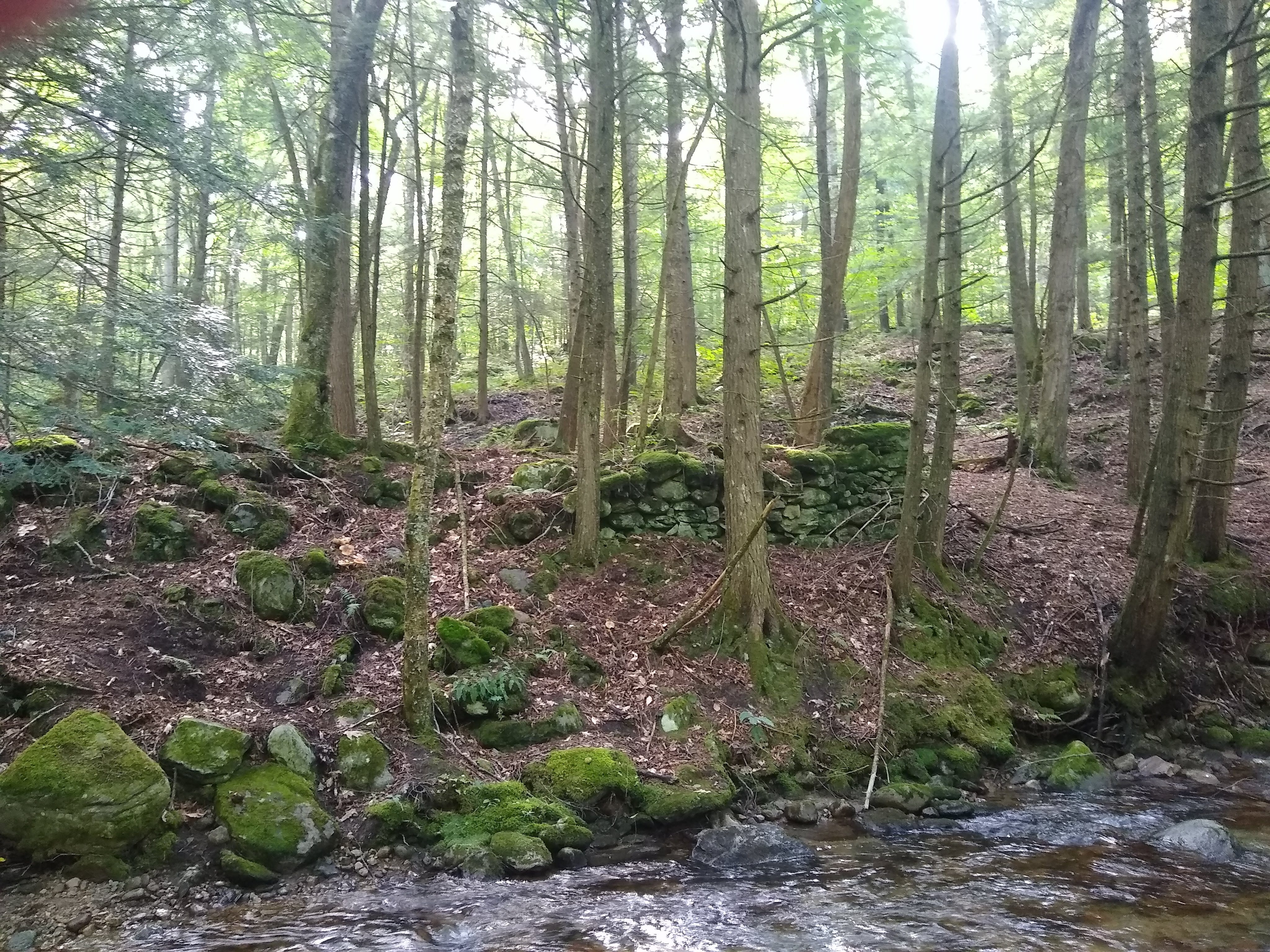
There is a graveyard hidden in the ferns and hemlocks a couple hundred feet away. The carvings name people who lived back in this hidden valley in the mid-1800’s. Mendon town records indicate that most were victims of a single Diphtheria epidemic. I see the stone walls disappearing into the forest across the road. Walls like the ones in my childhood backyard. I realize that 150 years ago there were probably no trees here, and these fields would have been full of sheep and crops. This is not “virgin” old-growth forest. This isolated land has been ravaged by extraction: first logging, then grazing. That is why the catamounts are gone.
As I run on, an old concrete dam, maybe more than a century old, creates a pond along the roadside. Was there a mill? Records say there were sawmills in this valley. I’d found an old stone foundation down by a ford in the river on another run. A big house stands up the slope overlooking the pond, the lawn neatly trimmed up to its edge. If you look it up on Zillow it is for sale, more than half-a-million, solar powered and off-grid, original 19th-century farmhouse with modern amenities. There are still houses out here, some modern, some old, some primitive hunting camps, all for people who want to get away from the rest of the world.
I come to the sharp bend in the road called Brewers Corner. Odd that a bend in the road in the middle of a forest would be named after someone. There is a “Brewer” among the names of the earliest white settlers of Mendon, of which Wheelerville is a part. Maybe this was their farm. This is where the watershed splits – Brewers Brook flows north into Mendon Brook just up the road, and the North Branch Cold River flows south through McLaughlin Falls into the notch. During Hurricane Irene, little Mendon Brook took two of the seven lives lost in Vermont.
There is a parking lot with a trailhead at Brewers Corner. I don’t remember this being there when I was running by at cross-country practice, but maybe I wasn’t paying attention. The Bucklin Trail. The first mile is a flat, boggy double track, possibly a road at one time. Some sections are completely flooded. Then the trail veers off to the left and begins climbing, wooden planking bridging the little streams and bogs amid the tree roots. The trail gets steeper as I go. The last mile is a power hike over rocks and roots, leaning forward, hands on my knees for leverage. I come to a junction where there is an old stone shelter – the Appalachian Trail/Long Trail passes here. Hikers trekking through on their way from Georgia to Maine or Maine to Georgia. If Maine isn’t your jam you can bear left at Maine Junction in Sherburne Pass just north of here and take the Long Trail all the way to Canada.
The Bucklin Trail keeps going up. A hand over hand scramble over boulders, almost straight up. I look back over my shoulder and I am above the trees. A green blanket of forest spreads out between me and the long ridge that is East Mountain, the mysterious barrier I had longed to fly over as a kid. Now I am on the other side, leaning against the side of Killington Peak at the roof of the Green Mountains, soaring.
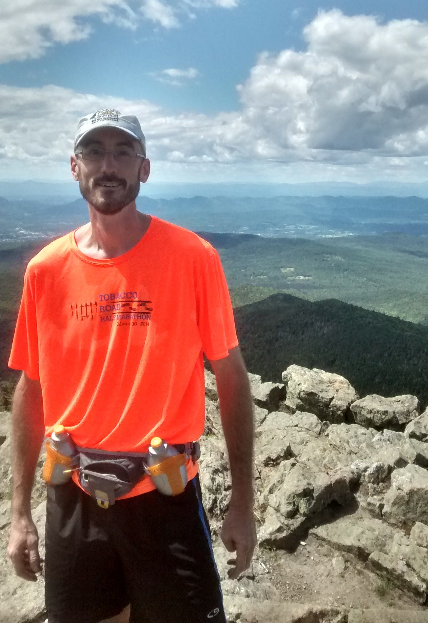
It had been warm and muggy down below. Now the whipping wind raises goosebumps on my bare arms. I step out onto the bare granite expanse with its windswept junipers, bright green lichens, satellite tower, and humming gondola machinery. The summit is crowded. I ask an obliging tourist to snap a photo. I gaze off to the White Mountains of New Hampshire and the spine of the Green Mountains as they disappear into the haze to the north. Across the Valley of Vermont where my hometown lays, the Taconic and Adirondack Mountains roll away to the west.
Most of the folks around me on the peak have reached the summit by gondola. I feel a little smug – the Bucklin Trail up the dark side of Killington isn’t for the faint of heart. But it’s also satisfying to make it to the top and share the experience with others. Just a few steps back down and the swanky resort world on the other side is gone again. Back down into the quiet, dark, lush forest below.
As a kid running around the yard it never occurred to me to wonder where the stone walls and barbed wire and concrete wells came from. I did sometimes wonder what the place had been like before there were houses and yards. I even remember wondering if there had ever been Indians there. You know, the “extinct” kind, like the ones I saw in the old movies being shot down by white men. Watching the Last of the Mohecans, there were some place names I recognized as being nearby. Turns out Rutland is situated on Mohecan and Abenaki land, and a Mohawk man had a role in the founding of the town.
In high school, the first time I ran up the Notch during cross-country practice, I ran for the Rutland Red Raiders, our mascot an Indian head with a stereotypical Lakota headdress. It was later changed to an arrowhead with an ‘RR’ in the middle. People thought that would somehow be less offensive. Nobody ever taught us about the real Native peoples whose lands we were building houses and lawns and high schools on. Native peoples who still exist carry on their traditions in different corners of the state, and have been sending their children to our schools. But we didn’t care to know, because to us, they were extinct. We didn’t learn in history class about the actual raids the Abenaki people used to successfully protect these lands from colonization for a century. People in Rutland are trying to get the mascot changed. After some initial success the backlash came: Raiders flags sprouted in people’s houses next to their Trump signs. Then they finally let the students vote. Tired of the controversy and haggling over alternative team names, they came back with “no mascot.”
Up the Notch the land has healed, is healing. Whatever kind of bustling place Wheelerville was, with its industry and farms and open fields for sheep and cattle, it is gone now, buried in those cemeteries overgrown by moss and ferns and grass and hemlock and pine. The stone walls are habitats for the tunnel spiders and chipmunks and a myriad of plants. They are signs that this place had been shorn of its trees to build ships and cities, to create meadows where the latest cash crop could roam and graze. The sheep pastures are lush forests again. Deer and black bear and foxes and bobcats abound. The barbed wire is rusting away along with the mysterious machinery half-buried in the ground. Much of it is protected state and municipal land. Now when I run up the Notch I get a glimmer of hope that there is life for the land beyond extractivism. This was a land burned twice over by settler colonialism – first by clearcutting timber, then by industrial wool production.
My relationship to this place reminds me never to be oblivious to the land. Never to simply take for granted the shape of its topmost layer. Maybe that’s why East Mountain and Bald Mountain fascinated me so much, sitting in my bedroom on a cul-de-sac in a new neighborhood built on former farm fields at the base of a vast mountain forest. Maybe that feeling I got when gazing at those mountains was the land showing itself, beckoning me to know it, showing me what the future could be if we let our lawn go. Heck, I only needed to look at my back yard to see that: half was mowed lawn, half was former pasture reclaimed by forest, the ground untouched by sunlight except in the winter. Except that I didn’t know what I was looking at at the time.
These days lots of people are setting up game cameras in their back yards and the footage has been revelatory: black bear, foxes, bobcats, deer, fisher cats, all venturing down off the Notch to hunt and forage in the neighborhood.
It would be typical at this point to romanticize the contrast between human and nature, civilization and the wild, and situate my childhood home as a liminal site, as a boundary point between dual realms. That feeling I had about the mysterious mountains could be the call of the wild to the pioneer, and the animals coming down from the mountain into civilization could be tragic, doomed invaders from the past, coming for its birdseed and trash. That would be a trope repeated by every colonial settler and storyteller of the tragic Indian: at its base, racist, colonialist.
What I want to say is maybe the opposite: my hope is that in some sense, the land beyond the Notch represents our future. The so-called civilization that Western settler colonial capitalism has created cannot survive. It has no future. I want to believe in the capacity of the land to heal itself. I want to believe in our capacity as humans to be part of the land, to care for it and be cared for in turn. The land I connect to when I run up the Notch is a healing place, a land that is thriving generations after being obliterated by settlers. Sure, it isn’t the same. It is no longer the primeval old-growth forest that the Indigenous people of Vermont remember, but it is vibrant and living and worth protecting and revering.
If you ever visit my hometown, by all means, go up the Notch. I hope if you get the chance to go there you will see something of what I have been trying to see. Maybe you’ll see something that I, as someone who grew up in its shadow, have been unable to see for my closeness. But however you visit – by car, by bike, or on foot – please visit with respect and reverence.